> ## Content Index
> Fetch the complete content index at: https://blog.afi.io/llms.txt
> Use this file to discover other available public pages before exploring further.
# Build an isochrone map with the Google Isochrone API
- URL: https://blog.afi.io/blog/build-an-isochrone-map-with-the-google-isochrone-api/
- Published: 2026-08-09T02:15:00.000Z
- Updated: 2026-11-11T02:17:48.000Z
- Description: Use the Google Maps Isochrone API to build an isochrone map that shows how far you can drive, bike, or walk in a set amount of time.
- Author: Afian Anwar
- Tags: googlemaps
In this post, you'll use the [Google Isochrone API](https://developers.google.com/maps/documentation/isochrones/overview?ref=blog.afi.io) to build a map of everywhere you can drive, bike, or walk to in a set amount of time. Use it to find an apartment near work, a hotel near the conference center, or the best site for a new store. Like most of our tutorials, I've included full source code (frontend / backend - coming soon!) that you can use in your own projects.
Part 1: [Mapping travel time with the Google Maps Isochrones API](https://blog.afi.io/blog/mapping-travel-time-with-the-google-maps-isochrones-api/)
Part 2: [How isochrones work: From shortest paths to polygons](https://afi.io/blog/how-isochrones-work-from-shortest-paths-to-polygons?ref=blog.afi.io)
**Part 3: Build an isochrone map with the Google Isochrone API (this article)**
[Show how far you can travel from a point in a set amount of time using the Google Isochrones APIMapping travel time and reachability with the Google Isochrones API](https://google-isochrones-demo.afi.dev/?ref=blog.afi.io)
### What is an isochrone map?
An isochrone map calculates the area reachable within a specified amount of time from a given location. And because it follows the real road network instead of drawing a straight line radius, it captures the roads, highways, traffic patterns, and transportation modes that affect how long it takes to get somewhere.
### Building an isochrone map using the Google Isochrone API
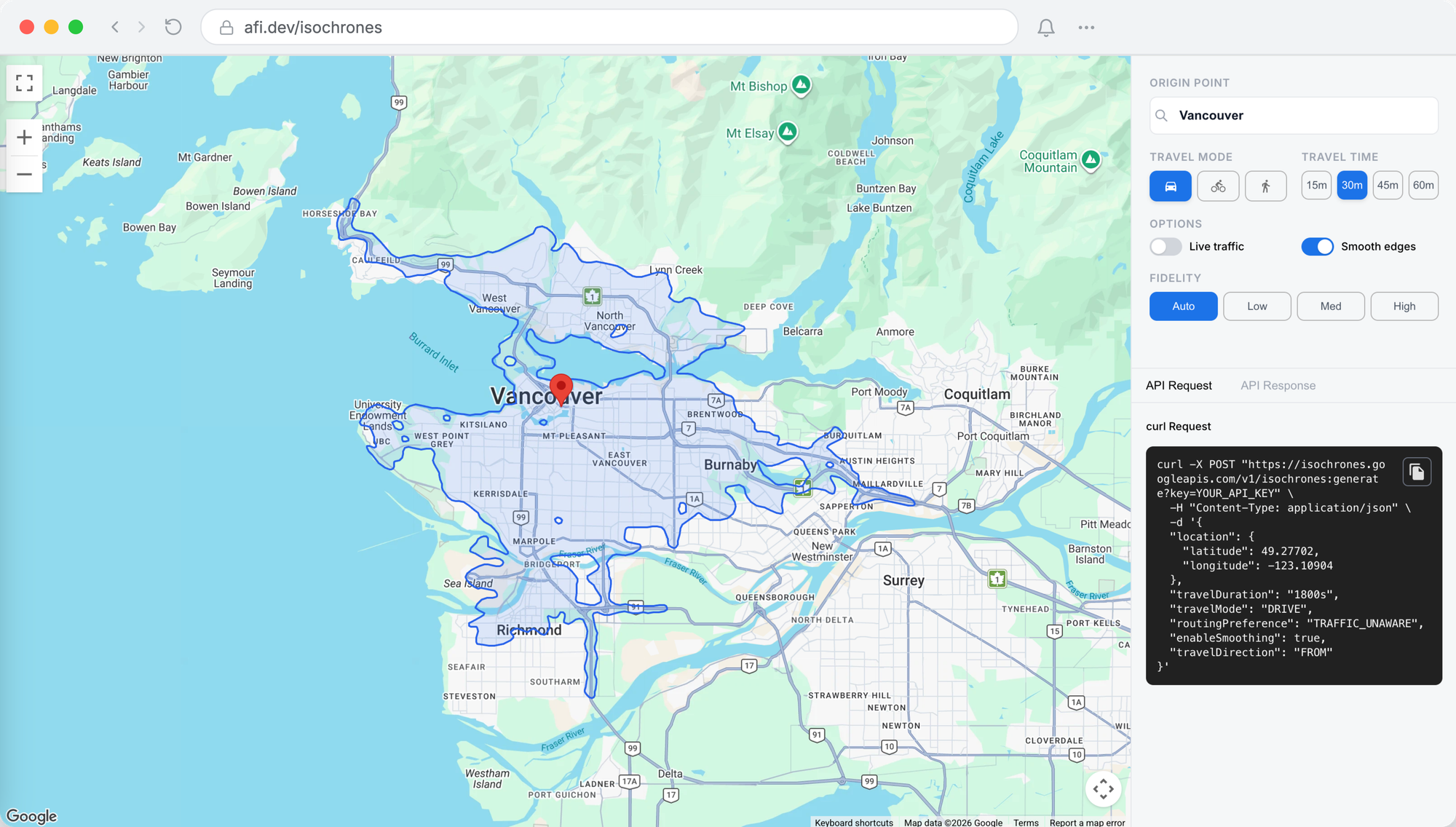
In this post, you’ll build a copy of the official [Google Maps Isochrones API demo](https://developers.google.com/maps/documentation/isochrones/demo?ref=blog.afi.io). Users enter a starting location, choose a travel mode (drive, bike, or walk), and set a travel time to see the area they can reach. The app also supports the API’s advanced options: live traffic, edge smoothing, and polygon fidelity.
### How the code for our isochrone map is organized
There are two parts to the app, a web frontend (google\_isochrones\_frontend - coming soon!) that handles user input and renders the isochrone, and a small backend (google\_isochrones\_backend - coming soon!) that makes the call to the [Isochrones API](https://developers.google.com/maps/documentation/isochrones/overview?ref=blog.afi.io).
**App.jsx**
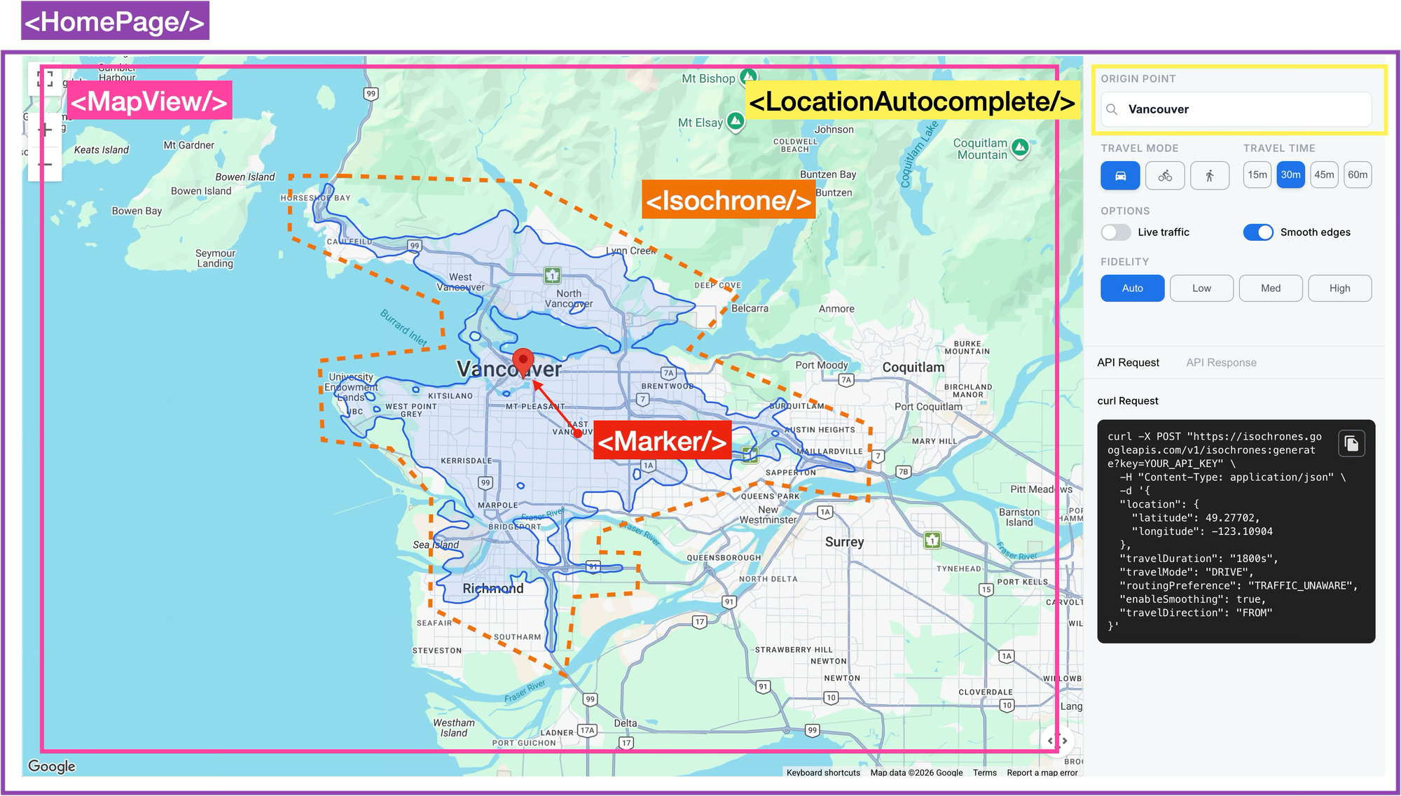
`App.jsx` is the main entryway (via `main.jsx`) to our app. It wraps everything in ``, which loads the Google Maps API, and renders ``.
```
/*** App.jsx ***/
import React from "react";
import { APIProvider } from "@vis.gl/react-google-maps";
import HomePage from "./pages/HomePage";
const API_KEY = import.meta.env.VITE_GOOGLE_MAPS_API_KEY || "";
function App() {
return (
);
}
export default App;
```
**HomePage.jsx**
The `` component does a whole lot more than just render `` (the Google Maps layer), `` (the address selector) and the sidebar configuration panel. It holds the app state: origin (`markerPosition`), `travelMode`, `travelDuration`, smoothing and real time traffic settings (`routingPreference`), and much more. It also triggers a new isochrone request whenever any of those change.
```
/*** pages/HomePage.jsx ***/
// Fetch a new isochrone whenever the origin or any setting changes
useEffect(() => {
if (!markerPosition) return;
let cancelled = false;
fetchIsochrone({
position: markerPosition,
travelMode,
travelDuration,
routingPreference,
enableSmoothing,
}).then((data) => {
if (!cancelled && data) setPolygonData(data);
});
// If settings change before this request finishes, ignore its response
return () => {
cancelled = true;
};
}, [
markerPosition,
travelMode,
travelDuration,
routingPreference,
enableSmoothing,
fetchIsochrone,
]);
```
After each render, React compares the values in the `useEffect` dependency array with their previous values. If any have changed, it re-runs the effect. So once an origin is set, clicking a different `travelMode`, `travelDuration`, toggle or `enableSmoothing` updates a piece of state and triggers a new request.
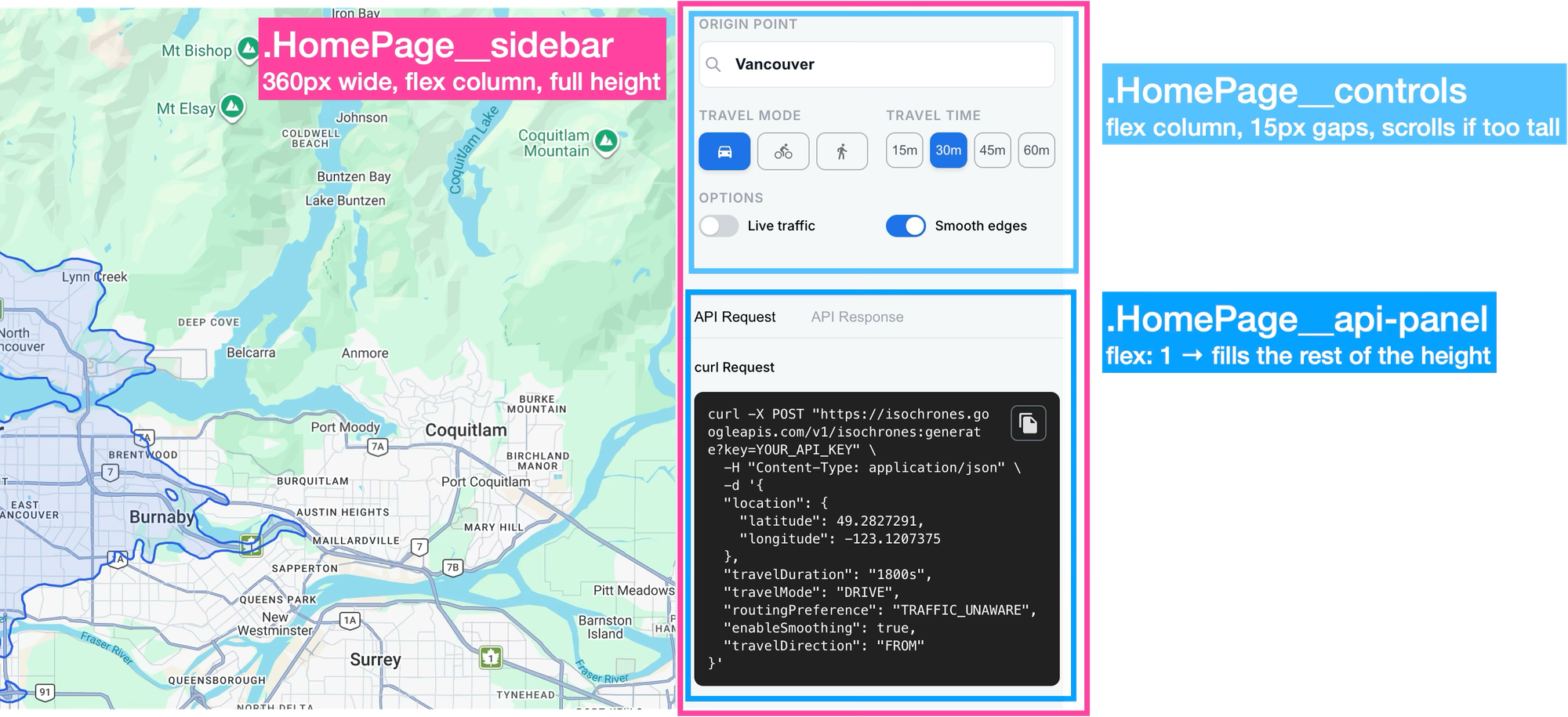
The sidebar is a fixed width column on the right of the screen, split into two stacked areas. The top area holds the controls; the bottom area is the API panel, which fills whatever height is left. The controls section turns each click into a state update, which triggers the fetch effect. The API panel displays the curl command and the response, with copy buttons.
```
/*** pages/HomePage.jsx ***/
{/* Origin: search box sets the isochrone's starting point */}
{/* Travel mode: one button per mode; clicking sets state */}
{TRAVEL_MODES.map((m) => (
))}
{/* Travel time: same pattern */}
{DURATIONS.map((d) => (
))}
{/* Live traffic toggle: disabled unless travel mode is DRIVE */}
{rawResponse ? JSON.stringify(rawResponse, null, 2) : 'Generate an isochrone to see the API response...'}
)}
```
Keeping the sidebar inline is simpler because all the settings state lives in `HomePage.jsx`, and the sidebar reads and modifies almost all of it. Kept inline, the buttons and toggles can read values like `travelMode` and call setters like `setTravelMode` and `setTravelDuration` directly, without them being passed down as props. For a simple single page app, that’s more than enough.
**LocationAutocomplete.jsx**
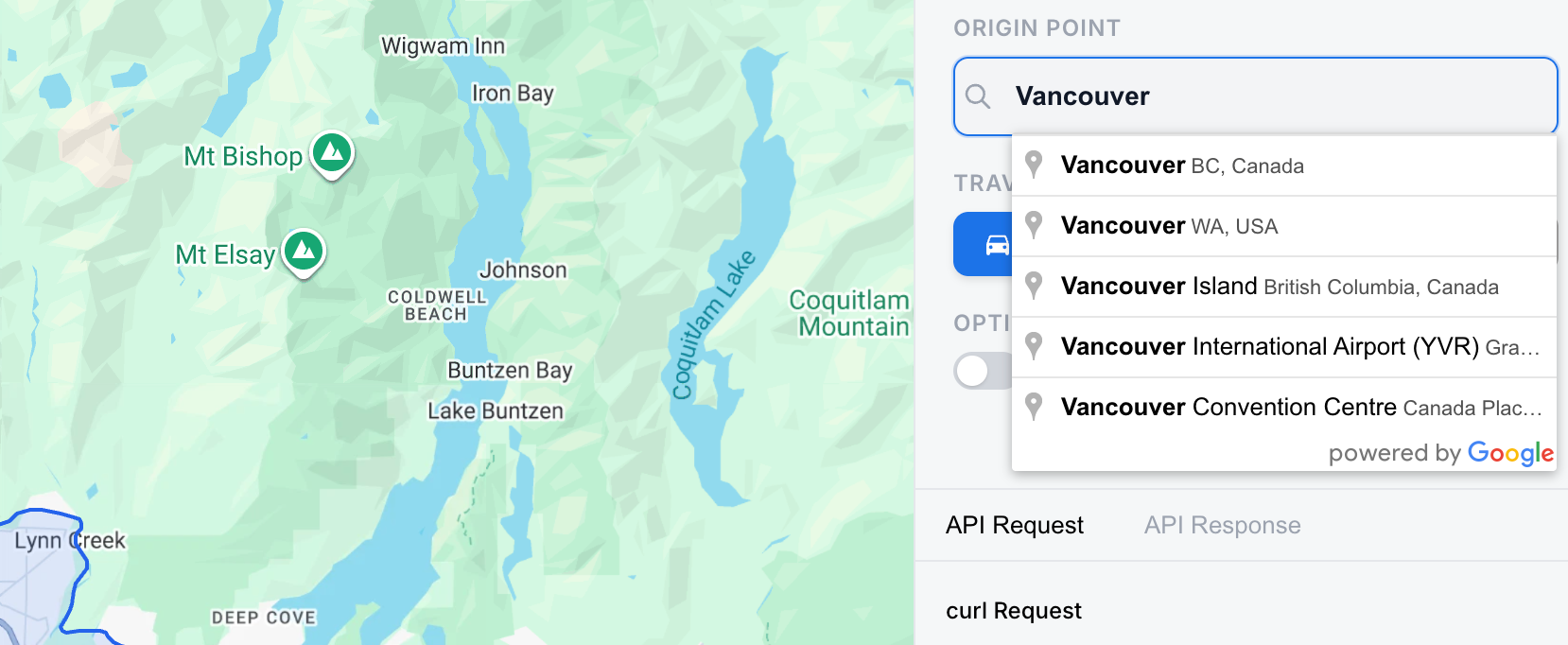
The `` component, as the name suggests, contains a text input field that uses [Google Places Autocomplete](https://blog.afi.io/blog/google-address-autocomplete-with-the-places-api/) to suggest places dynamically as the user types. Here's how this works:
1. The component renders a plain text `` and attaches a ref to it with `ref={inputRef}`, where `inputRef` is created with `useRef(null)`. Once the component is on the page, `inputRef.current` points to the actual input element, which is what Google’s Autocomplete needs to attach to.
```
/*** components/LocationAutocomplete.jsx ***/
return (
);
```
1. A `useEffect` hook waits for the Google Places library to finish loading (`useMapsLibrary('places')` returns `null` until it’s ready), then creates an Autocomplete instance on the input:
```
autocompleteRef.current = new placesLib.Autocomplete(inputRef.current);
```
1. The effect also adds a listener for the `place_changed` event to the Autocomplete instance. This event fires when the user selects a suggestion from the dropdown. The handler calls `getPlace()` to get the selected place, ignores it if it has no coordinates, and passes its position (`{ lat, lng }`) and `name` to the `onSelect` prop. In `HomePage.jsx`, `onSelect` is `handleLocationSelect`, which updates `markerPosition` and `locationName`, and that state change triggers a new isochrone request.
```
/*** components/LocationAutocomplete.jsx ***/
useEffect(() => {
if (!placesLib || !inputRef.current || autocompleteRef.current) return;
autocompleteRef.current = new placesLib.Autocomplete(inputRef.current);
const listener = autocompleteRef.current.addListener("place_changed", () => {
const place = autocompleteRef.current?.getPlace();
if (!place?.geometry?.location) return;
const name = place.name || place.formatted_address || "";
const position = {
lat: place.geometry.location.lat(),
lng: place.geometry.location.lng(),
};
suppressFillRef.current = true;
onSelectRef.current(position, name);
});
return () => {
google.maps.event.removeListener(listener);
autocompleteRef.current = null;
};
}, [placesLib]);
```
**useIsochrone.js**
Whenever the marker position changes (because the user selected a place in the search box or clicked the map), or any of the isochrone settings change, a `useEffect` in `HomePage.jsx` calls `fetchIsochrone()`. This function is returned by the `useIsochrone()` hook in `hooks/useIsochrone.js`. It builds the request and calls `generateIsochrone()` in `api/isochrones.js`, which sends it to the backend with an axios POST to the `/isochrones` endpoint.
```
/*** hooks/useIsochrone.js ***/
import { generateIsochrone } from "../api/isochrones";
const fetchIsochrone = useCallback(async (params) => {
setLoading(true);
setError(null);
try {
const request = {
latitude: params.position.lat,
longitude: params.position.lng,
travelMode: params.travelMode,
travelDuration: params.travelDuration,
routingPreference: params.routingPreference,
enableSmoothing: params.enableSmoothing,
...(params.polygonFidelity ? { polygonFidelity: params.polygonFidelity } : {}),
};
const data = await generateIsochrone(request);
// A 204 "no content" response doesn't throw in axios, it arrives as an empty body
if (!data?.polygons?.length) {
setError('No reachable area found for these parameters.');
return null;
}
return data;
} catch (err) {
if (axios.isAxiosError(err) && err.response) {
setError(err.response.data?.message || `Server error (HTTP ${err.response.status})`);
} else {
setError(err.message || 'An unexpected error occurred.');
}
return null;
} finally {
setLoading(false);
}
}, []);
const clearError = useCallback(() => setError(null), []);
return { loading, error, fetchIsochrone, clearError };
```
The `useIsochrone()` hook returns an object with four properties, the most important is `fetchIsochrone`, a function that sends the request to the backend, which then calls Google’s Isochrones API. It returns a promise that resolves to the response containing the isochrone polygon (`data.polygons`, below), or to `null` if the request fails.
```
{
"polygons": [
{
"travelDuration": "1800s",
"travelMode": "BICYCLE",
"geojson": {
"type": "MultiPolygon",
"coordinates": [
[
[
[
-123.10366188933581,
49.256439060502814
],
[
-123.1018689929727,
49.25634289023366
],
[
-123.09907399005446,
49.25656971737912
],
//... 157 more entries
]
]
]
}
}
}
}
```
The `useEffect` in `HomePage.jsx` saves it into `polygonData` state with `setPolygonData`, and passes `polygonData` as a prop to `MapView.jsx`.
```
/*** pages/HomePage.jsx ***/
;
```
**MapView.jsx**
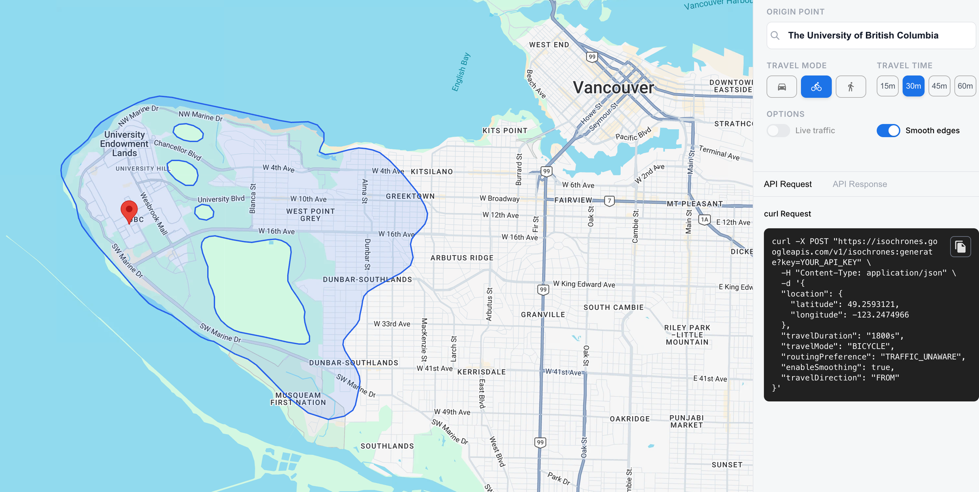
`MapView.jsx` renders a [ component](https://visgl.github.io/react-google-maps/docs/api-reference/components/map?ref=blog.afi.io) centered on Vancouver, BC. Once the user picks an origin (by search or by clicking the map), it shows a marker there and draws the isochrone polygon around it. It does this by passing in `polygonData` as a prop to the child `` component.
```
/*** components/MapView.jsx ***/
return (
);
```
**Isochrone.jsx**
`` draws the isochrone as a shaded area on the map. It doesn’t render any HTML of its own (it returns `null`). Instead, it draws directly on the map using the Google Maps API.
First, it gets the map with `useMap()`. Then, inside a `useEffect`, it:
1. Takes the `geojson` from the first entry in `data.polygons`,
2. Creates a `google.maps.Data` layer on the map,
3. Wraps the GeoJSON in a `Feature` and adds it with `addGeoJson`, and
4. Styles it light blue with a blue outline with `setStyle`.
```
/*** components/Isochrone.jsx ***/
import { useEffect } from "react";
import { useMap } from "@vis.gl/react-google-maps";
//... Function to compute isochrone bounding box
function Isochrone({ data }) {
const map = useMap();
useEffect(() => {
if (!map || !data?.polygons?.length) return;
const { geojson } = data.polygons[0];
const layer = new google.maps.Data({ map });
layer.addGeoJson({
type: "Feature",
geometry: geojson,
properties: {},
});
layer.setStyle({
fillColor: "#3B82F6",
fillOpacity: 0.15,
strokeColor: "#2563EB",
strokeWeight: 2,
});
//... Bounds calculation
return () => layer.setMap(null);
}, [map, data]);
return null;
}
export default Isochrone;
```
1. `HomePage` passes `polygonData` as a prop to `MapView`.
2. `MapView` passes it to `` as `data={polygonData}`.
3. In a `useEffect`, `Isochrone` gets the map instance with `useMap()` and takes the `geojson` field from the first entry in `data.polygons`.
4. It creates a `google.maps.Data` layer on the map, wraps the GeoJSON geometry in a `Feature`, and adds it with `addGeoJson`.
### Deploy and run
To test the app, simply visit [https://google-isochrones-demo.afi.dev/](https://google-isochrones-demo.afi.dev/?ref=blog.afi.io) and enter an address into the search box on the top right. If you'd like to run the app locally, fork both google\_isochrones\_frontend (coming soon!) and google\_isochrones\_backend (coming soon!) on GitHub and run `npm install` to install dependencies. Start the app by running `npm run dev` in each folder, then open [http://localhost:5173/](http://localhost:5173/?ref=blog.afi.io) in your browser to view it. Remember to update the `.env` files in both repos with a Google Maps API key that has both the Places API and Isochrones API enabled.
### Isochrone maps in real world apllications
At the time of writing (November 2026), the Isochrones API is still in pre-GA Preview, and it has two notable gaps. It doesn’t support public transit, so it can’t account for bus or train schedules. And there’s no way to set a departure time. Live traffic reflects conditions at the moment you make the request, so you can’t ask, for example, how far you could drive at 8am on a weekday during rush hour.
That being said, its still incredibly useful. A property search portal could use it to help users look for homes within a 30-minute commute of their office or their children’s school, which is what most buyers and renters actually care about. City planners can use isochrones to see how much of a city can reach a hospital, a school or a park on foot or by bike, and where those services are hard to get to. If you have new or interesting use cases for the [Isochrones API](https://developers.google.com/maps/documentation/isochrones/overview?ref=blog.afi.io), or have general questions about the Google Maps APIs, please [reach out](https://www.afi.io/contact%5Fus?ref=blog.afi.io)!
Part 1: [Mapping travel time with the Google Maps Isochrones API](https://blog.afi.io/blog/mapping-travel-time-with-the-google-maps-isochrones-api/)
Part 2: [How isochrones work: From shortest paths to polygons](https://afi.io/blog/how-isochrones-work-from-shortest-paths-to-polygons?ref=blog.afi.io)
Part 3: [Build an isochrone map with the Google Isochrone API](https://blog.afi.io/blog/build-an-isochrone-map-with-the-google-isochrone-api/)
**This article was written by** [**Afi Labs**](https://afi.io/?ref=blog.afi.io)**, a** [**Google Maps Premier Partner**](https://www.afi.io/?ref=blog.afi.io) **and reseller. We build route optimization, navigation, and fleet tracking software on Google Maps, and offer volume pricing on GMP licensing.** [**Talk to an engineer**](https://www.afi.io/contact%5Fus?ref=blog.afi.io) **or** [**follow Afian on LinkedIn**](https://www.linkedin.com/in/afian-anwar/?ref=blog.afi.io)**.**